
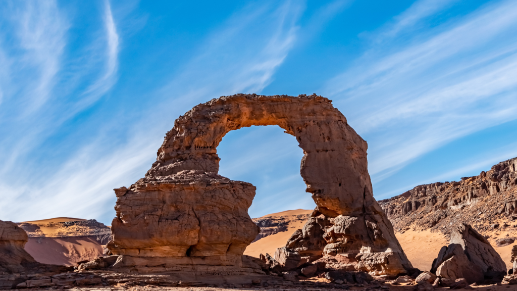

Djanet is the oasis town in Algeria's far southeast where trips into the Tassili n'Ajjer begin. The main things to do are a 4x4 trip to the red dunes of the Tadrart Rouge, a trek to the rock art of Sefar or Jabbaren, a day at the Essendilène canyon and the "Crying Cows" engraving, and an afternoon in the old ksour and palm grove in town.
Below we go through each one, then the visa, flights, packing and the best months, because Djanet takes more planning than the north.
The north of the country, from Algiers to Constantine, is covered in our Algeria travel guide.
The Djanet trip in outline
Djanet sits at about 1,035 m in Algeria's far southeast, below the Tassili n'Ajjer plateau, and most people reach it on an Air Algérie flight from Algiers of a little over two hours, landing about 30 km south of town.
Unless you already hold a consulate visa, you come in on the visa on arrival, which is only issued for organized trips through an approved Algerian agency (about EUR 110, depending on nationality). The season runs from late October to April, and November or late February to March are the sweet spots. Give it a week at the very least, and 10 days or more if you want the Sefar trek.
Tadrart Rouge: Red Dunes and Rock Arches
About 200 km southeast of Djanet rises the Tadrart Rouge, a sandstone range that carries on into Libya as the Tadrart Acacus. Its dunes run from apricot to deep red, and the color changes with the light through the day.
Most people visit on a 4x4 trip of several days, camping out with a Tuareg crew from Djanet who know every valley by name. Ours work exactly like that, through a licensed local agency on routes we know well, and not one of them has had an incident. Most of the people we take into the Tadrart say afterward that it felt calmer and friendlier than anything they had read before they came.
On the way in, most drivers stop at the Tamezguida arch, which Tuareg guides call "the Cathedral" for its gothic shape. It frames the desert beyond it and is one of the best photo stops in the area. Ask your driver for time to walk underneath it: the scale only registers on foot.
Further into the Tadrart is Moul n'Aga, a name usually translated as "the owner of the camel." The reason is a rock formation on top of the dune that looks like a camel resting in the sand.

Most trips end with the climb up Tin Merzouga, one of the highest dunes in the Tadrart. Go in the late afternoon. It's a hard slog in soft sand, and from the top you see red dune ridges in every direction. After sunset the sand turns purple-gray, it goes very quiet, and it gets cold fast, so bring a layer up with you.
Trek to the Rock Art of Sefar and Jabbaren
The Tadrart is about landforms; the Tassili n'Ajjer plateau is about people. UNESCO, which made it a World Heritage site in 1982, has counted more than 15,000 drawings and engravings on it. They were made over a very long stretch, from roughly 10,000 BC into the first centuries AD, and together they form one of the largest bodies of prehistoric rock art anywhere.
If you have the legs for it, we'd pick the trek to Sefar. Its eroded sandstone pillars and corridors look like streets and houses, which is why it's called a "stone city," and the walls hold some of the best-known Round Head paintings: large, featureless human figures that have attracted all sorts of theories.
The classic route climbs onto the plateau from near Djanet by the Akba Tafilalet pass and Tamrit, where Saharan cypresses (tarout) grow in the wadis; the oldest are estimated at over 2,000 years. Donkeys carry the gear, and walking itineraries from Djanet usually take 8 to 10 days there and back.

Jabbaren is the other big site, and many treks combine the two. The name means "the giants" in Tamahaq, after the huge human figures painted on the rock.
Henri Lhote, the French ethnographer who copied the Tassili paintings in 1956 and 1957, nicknamed one of them the "Great Martian God," and ancient-astronaut writers later ran with it; it most likely shows a person in a ritual mask. Reaching Jabbaren means climbing onto the plateau by the Akba Aroum, a steep pass, but anyone with reasonable fitness can do it. Up top, panel after panel shows cattle herding, hunting and dancing from the Bovidian (pastoral) period, painted when this desert was grassland with water.
See the "Crying Cows" of Tegharghart
About 25 km from Djanet, on the edge of the Erg Admer, is the engraving most visitors remember: the "Crying Cows" (La vache qui pleure) of Tegharghart. It's carved in bas-relief with deep grooves and is usually dated to more than 7,000 years ago, in the Neolithic.
It shows a small herd of long-horned cattle leaning toward a hollow at the foot of the rock, as if waiting for water. Lines under the eyes of some of the cows read as tears. The Tuareg story is that the cows are crying because they came back and the water had gone. Many writers connect the scene to the drying of the "Green Sahara," but nobody can prove what the artist meant.
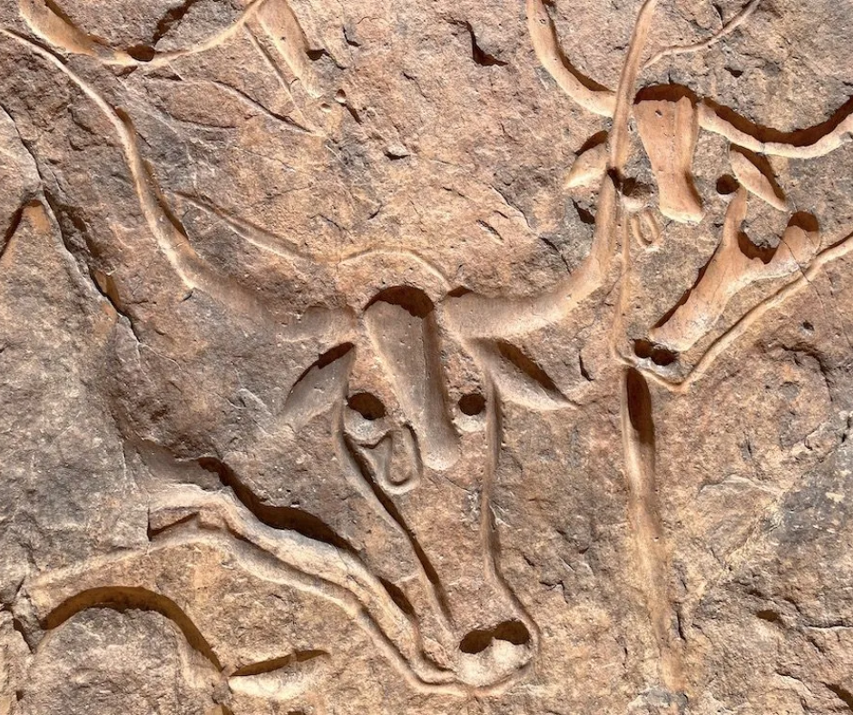
Because it's close to town, it fits easily into your first or last day, and half an hour on site is enough. Pair it with the Erg Admer, the dune field just west of Djanet, for the easiest dune outing from town: a half-day with the engraving in the afternoon and sunset from the crest of a dune.
Essendilène Canyon and Its Guelta
After days of open dunes, water feels like an event. Essendilène is a canyon roughly 80 to 100 km northwest of Djanet (sources vary), usually done as a long day trip or with one night out. You walk up a narrowing gorge where the rock walls give welcome shade.
Further in, pink-flowered oleanders line the wadi, along with wild figs, date palms, acacias and tamarisks. They grow here because water collects in gueltas, rock pools that hold water long after the rare rains.

At the end of the canyon is the main guelta, a pool of clear, cold water under the rock walls and a good place for lunch. We'd skip swimming: herders and wildlife depend on these pools, so keep soap and sunscreen out of the water.
It's noticeably cooler down here than in the open desert. Of the trips out of Djanet, this is the gentle one: shade, water and a walk at your own pace.
The Gueltas of Iherir Valley
For more of the same contrast, go to the Iherir Valley, about 150 km from Djanet. It's a valley between high cliffs where a chain of gueltas is linked by a thin stream, and the canyon floor is green. Iherir has been a Ramsar-listed wetland since 2001. It's farther out than Essendilène, so fewer visitors make it, and agencies usually combine the two on a trip of several days.
Adding the Hoggar Mountains
If you have extra days, the Hoggar is a separate trip, centered on Tamanrasset, roughly 450 km southwest of Djanet as the crow flies. Algeria's highest summit is here, Mount Tahat (usually given as 2,908 meters), and so is the Assekrem plateau, about 2,726 meters up, where Charles de Foucauld built a hermitage in 1911.
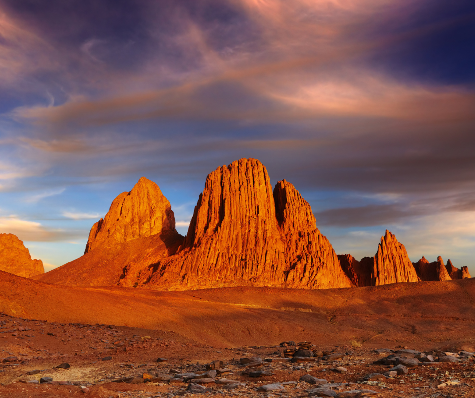
The landscape is dark volcanic peaks rather than Tassili sandstone, and Domestic Airlines flies between Djanet and Tamanrasset on some days of the week. The rules match Djanet's: you go with an approved agency and local guides, and if the authorities assign a police or gendarmerie escort on your route, the agency sets it up. For a wider view of the desert, from the Hoggar to the Grand Erg Occidental, see our Algerian Sahara travel guide.
Tuareg Culture: Tea, Taguella and the Sebeïba
Djanet is the main town of the Kel Ajjer, the Tuareg of this region, and on most trips your guide and camp crew will be from here. Much of what you learn about Tuareg life will come from evenings around their fire.
Tea is the center of those evenings. It's brewed in three rounds over the embers, and each glass is poured from high up so the tea foams. A common saying, told with small variations, describes the three glasses: the first bitter like life, the second sweet like love, the third gentle like death. Don't rush it: a full round of three takes a while.
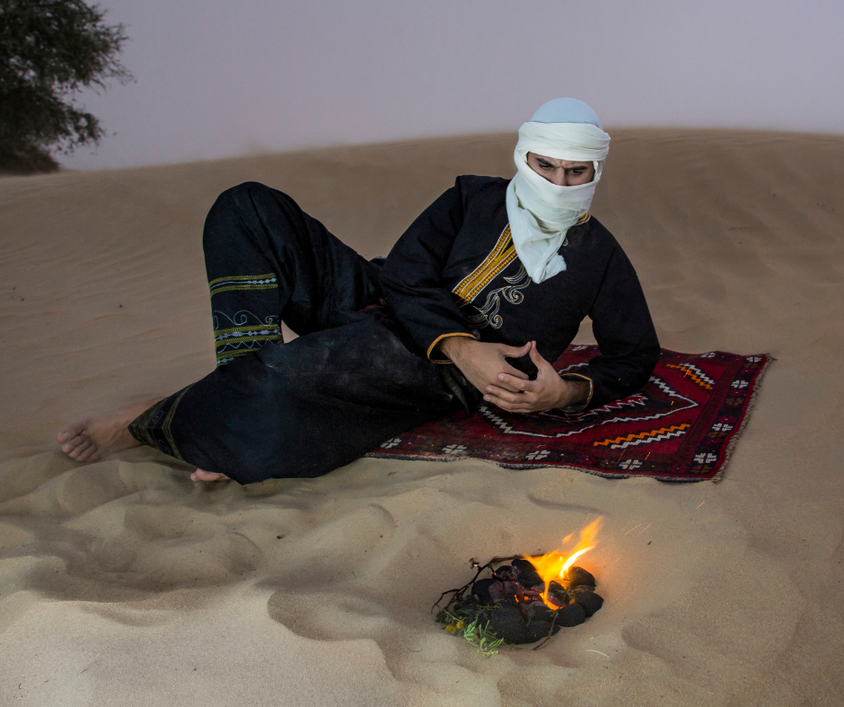
Ask your cook for taguella, the Tuareg bread baked under sand and embers. The dough (flour or semolina and water) goes under the fire, then gets dug out, brushed clean of sand, broken into pieces and covered with a sauce of meat and vegetables. It's eaten from a shared dish, usually after dark.
The big event of the year is the Sebeïba, held on Ashura (10 Muharram). It's a drum, song and dance contest between two of Djanet's ksour, Azelouaz and El Mihan.
Local tradition links it to the end of an old rivalry between them and to the Ashura story of Moses and Pharaoh. The men parade in warrior dress with swords while the women sing and play the drums, and UNESCO added the ritual to its Intangible Cultural Heritage list in 2014.
The catch is the date. It follows the lunar calendar and moves about 11 days earlier each year, so the next one falls around 15 June 2027, when Djanet's average daytime high is close to 38°C. Come for it only if you can handle the heat.
Ride Out on a Camel Trek
For a slower pace than the 4x4, switch to a camel for a day or more.
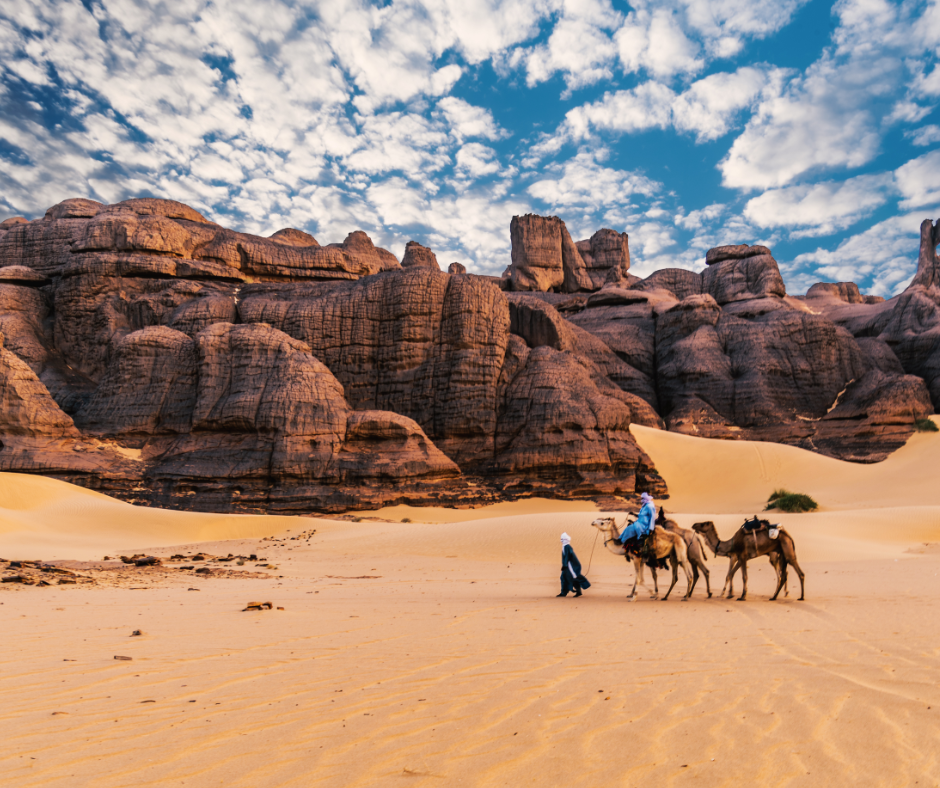
At walking speed you notice things a vehicle drives past: a line of engravings on a cliff face, a side valley between the dunes. If you have never ridden a camel, start with a few hours rather than several days.
Djanet Town: the Ksour, Palm Grove and Market
Djanet town is worth half a day between desert trips. Start in the palm grove along the Oued Idjeriou, where around 40,000 date palms shade small gardens. Besides dates, they grow vegetables such as potatoes and tomatoes, plus olives and citrus.
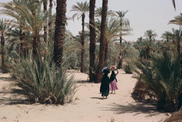
The town climbs the rocky slopes on either side of the wadi, above the palm grove.
Walk up through the old ksour (fortified villages) of El Mihan or Adjahil. Their mud-brick houses climb the hillside, many of them now in ruins, and the narrow lanes photograph best in low morning or evening light. If you like this kind of earthen architecture, the red ksar of Timimoun, far to the west, is built in a completely different style.
The third ksar, Azelouaz (also spelled Zelouaz), sits nearby along the Idjeriou.
Local tradition dates the three villages to the 16th century, with Adjahil the oldest. They were the settled core of the oasis, where farming families worked the palm gardens.
Under French rule Djanet was called Fort Charlet, after Captain Édouard Charlet, whose camel corps took the oasis in November 1911. It is still the main town of the Kel Ajjer Tuareg.

The market in the center is the place to buy dates from the palm grove and Tuareg crafts such as leatherwork and textiles. Djanet and Ghat, just across the Libyan border, were relay stops on the trans-Saharan caravan routes, and goods from southern Libya and Niger still pass through town.
Look for silver jewelry, a Tuareg specialty: rings, pendants and the well-known Tuareg crosses, with geometric designs traditionally worn for protection. Buy a cheche (the long Tuareg headscarf) and have someone show you how to tie it. You'll wear it every day against sun and blown sand.
Round off your time in town at the small museum of the Tassili park office in El Mihan. It covers geology, prehistory and Tuareg life, which is useful context before or after the rock-art sites. Opening hours are short (reported as weekday mornings, Sunday to Thursday), so ask your agency to check before you go.
Sample Djanet itineraries
These are the shapes most Djanet trips take. Exact days depend on flight days, the season and how much you want to walk, and every route runs with a licensed agency, a Tuareg guide and a camp crew.
| Trip length | Typical route | Nights out |
|---|---|---|
| 4 days | Day 1: arrive, palm grove and ksour. Day 2: the Crying Cows and sunset on the Erg Admer. Day 3: Essendilène canyon and its guelta. Day 4: market and museum, fly out. | 0 to 1 (a night at Essendilène is optional) |
| 7 days | Day 1: arrive. Day 2: the Crying Cows. Days 3 to 6: 4x4 loop in the Tadrart Rouge (Tamezguida arch, Moul n'Aga, Tin Merzouga). Day 7: town and fly out. | 4 in the desert |
| 10 days | Either the 4-day plan plus a longer Tadrart loop and Iherir by 4x4, or a trek onto the plateau to Sefar or Jabbaren with donkeys carrying the gear. | 6 to 9 in the desert |
Djanet Logistics: Visa, Flights, Packing and Timing
Djanet needs more preparation than northern Algeria: the visa runs through an agency, and you will almost certainly fly in.
The Visa Process
Sort this out first. You can't just turn up in Djanet and buy a visa. For most Western nationals there are two routes: a regular tourist visa from an Algerian consulate, issued before you leave, or the southern visa on arrival. That second option needs an organized trip booked through an approved Algerian travel agency.
The agency files your passport details on the Tourism Ministry platform and sends you a QR-code authorization, often called the "boarding pass," which you show the airline when you check in. You pay the visa fee on arrival, in Djanet or in Algiers if you land there first. The fee depends on nationality (EUR 110 is the figure you'll see most often), and the visa covers the dates of your trip, up to 30 days.
For the consulate visa and current safety advice, this guide to Algerian Visa, safety and security goes into more detail.
Officially, the visa on arrival is the "visa de régularisation." It started in late 2022 for 11 southern wilayas, Djanet among them, and was extended to 24 wilayas from March 2023.
Getting There
Most travelers fly into Algiers (ALG) and connect to Djanet (DJG) with Air Algérie; the flight takes a little over two hours. Some departures are late at night or very early in the morning, and domestic schedules change often, so leave a buffer between your international and domestic flights.
Expect your agency to be waiting at Tiska, Djanet's airport, about 30 km south of town. In recent Saharan seasons (roughly late October to May) Air Algérie has also run seasonal direct flights between Paris CDG and Djanet, so see whether they're on sale for your dates. Djanet is on the network of Domestic Airlines too, the Air Algérie subsidiary that took over from Tassili Airlines in 2025 and flies the Tamanrasset link.
Seats sell out fast in high season, so book early. If you would rather see more of the Sahara on the way, our Algeria desert road trip takes in Taghit and Timimoun before ending in Djanet.
What to Pack
Days are hot and bright even in winter, but nights are cold: Djanet's average January low is about 3.5°C, and it has dropped below -7°C. You need layers and a sleeping bag rated for near-freezing nights. Bring broken-in hiking boots, because the terrain runs from soft sand to sharp, abrasive sandstone. Pack a headlamp for camp and a power bank: on a camping trip you'll be off the grid for days, and phone coverage is patchy or absent once you leave town (Mobilis usually reaches furthest).
For clothing and local dress norms, our guide on what to wear in Algeria covers the rest.
When to Go
The season runs from late October to April. Average highs in Djanet are about 20°C to 23°C from December to February, around 27°C in March and November, and around 32°C in October and April. From May to September they average 36°C to 38°C, which makes hiking and dune climbs hard work and, in midsummer, unsafe. We'd aim for November, or late February to March: warm days without the coldest nights.
Where to Stay
Camping is the classic choice, and on multi-day trips into the Tadrart or onto the plateau it is the only one. Agency camps range from simple tents to a bivouac, a desert camp with proper bedding and meals cooked by the crew. In town, Djanet has a handful of hotels and guesthouses, which work well for the first and last nights and for day trips to Essendilène or the Crying Cows.
Who Djanet Suits, and How to Plan It
Djanet suits people who are happy to camp, walk a few hours a day and spend most of the trip without phone signal. It suits you less if you want a hotel every night or only have a long weekend: with the connection through Algiers, we'd plan a week at the very least.
Djanet flights, guides, timing and safety
Where is Djanet, and why start there?
It's an oasis town in Algeria's far southeast, at about 1,035 m at the foot of the Tassili n'Ajjer plateau, and the capital of its own wilaya since the 2019 to 2021 reforms; the 2008 census counted 14,655 people. Every route to the Tassili rock art, the Tadrart Rouge dunes and the Essendilène canyon begins here.
How do I get to Djanet from Algiers?
Fly: Air Algérie takes a little over two hours, Domestic Airlines also serves the town, and your agency normally meets you at the airport, about 30 km south of the center.
Can I visit Djanet without an agency?
No. Foreigners in the south are expected to travel with an approved Algerian agency, and the visa on arrival is only issued for trips booked that way. The agency provides the Tuareg guide, driver and cook, handles permits and, on some routes, arranges the escort. You can't rent a 4x4 and head out alone.
What is the best month to visit Djanet?
November, or late February to March. Days are warm, around 23 to 27°C, and nights are cool rather than freezing. December and January are pleasant by day but drop to about 3.5°C at night. From May to September highs average 36 to 38°C, too hot for trekking.
Is four days in Djanet enough?
For the Crying Cows, Essendilène and the town, yes, but not for the desert itself: the Tadrart Rouge alone needs three to five days by 4x4, and the Sefar trek 8 to 10 days there and back, plus a night either side for flights. That's why we say a week at the very least.
Does Djanet feel safe?
Travelers on our Djanet trips regularly tell us it felt calmer and friendlier than they expected, and every one of those trips runs with licensed local agencies and Tuareg guides. Still, look up the official travel advice for the Djanet area before you pay a deposit, and confirm that your insurance policy covers the region.
Tell us your dates and how much walking you want, and we'll suggest a route and arrange the trip with our licensed partner agencies and Tuareg guides in Djanet, including the visa-on-arrival request, the pickup at Tiska airport and the camp crew. All you have to do is reach out to us from this page.


